Barbrook 2
Location
Big Moor
Derbyshire
OS Grid Reference - SK 2774 7582
The easiest route to this site is to pass though Barbrook 1, following these directions -
Park at the large lay-by @ circa SK 2807 7525 and taking care cross the road and enter the moor via a gate next to another distinctive large white gate, follow the vehicle track for around .5km till it turns noticeably left, the larger stones of Barbrook 1 should be visible to your right around 30 metres up hill onto the moor.
From Barbrook 1 you should be able to spot the large cairn around 30 metres NNE of it, make your way over to it and after having a wander around it go left where you'll see a narrow path leading North.
If you follow this path for around 200 metres NNW, passing several smaller kerbed cairns along the way you should be lead directly to Barbrook 2, the path is quite well worn now.
If you follow this path for around 200 metres NNW, passing several smaller kerbed cairns along the way you should be lead directly to the Enigma of Barbrook 2.
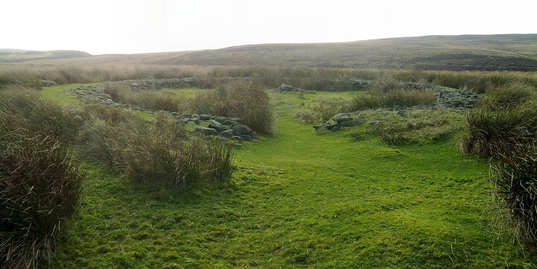
Barbrook 2 is unlike any other "circle" i've ever seen, imagine digging a flat bottomed pit with a diameter of around 15 metres, lining the interior earth walls with dry stone walling and then placing uprights within the walling that's how Barbrook 2 appears, a unique site indeed and unlike anything else within Derbyshire.
Some have suggested it's a sheep pen, hut circle and even a Burial enclosure which is somewhat backed up by the small interior cairn and cist, upon a part of the cists broken cap stone is a cup mark, maybe two and a small "chevron" carving.
The "circle" has a single entrance to the North East.
Due to vandalism in the late 80's the site was extensively restored to it's present state, other excavations took place in 1850 and 1967 through to 1970, amongst the finds were 4 human cremations with carbon dating evidence dating the burials to the Bronze age.
The site has a single entrance to the NNE,
Barbrook 2 is a "must see" site but take your wellies, the moor can be very boggy especially during the winter months.
Big Moor
Derbyshire
OS Grid Reference - SK 2774 7582
The easiest route to this site is to pass though Barbrook 1, following these directions -
Park at the large lay-by @ circa SK 2807 7525 and taking care cross the road and enter the moor via a gate next to another distinctive large white gate, follow the vehicle track for around .5km till it turns noticeably left, the larger stones of Barbrook 1 should be visible to your right around 30 metres up hill onto the moor.
From Barbrook 1 you should be able to spot the large cairn around 30 metres NNE of it, make your way over to it and after having a wander around it go left where you'll see a narrow path leading North.
If you follow this path for around 200 metres NNW, passing several smaller kerbed cairns along the way you should be lead directly to Barbrook 2, the path is quite well worn now.
If you follow this path for around 200 metres NNW, passing several smaller kerbed cairns along the way you should be lead directly to the Enigma of Barbrook 2.
Barbrook 2 is unlike any other "circle" i've ever seen, imagine digging a flat bottomed pit with a diameter of around 15 metres, lining the interior earth walls with dry stone walling and then placing uprights within the walling that's how Barbrook 2 appears, a unique site indeed and unlike anything else within Derbyshire.
Some have suggested it's a sheep pen, hut circle and even a Burial enclosure which is somewhat backed up by the small interior cairn and cist, upon a part of the cists broken cap stone is a cup mark, maybe two and a small "chevron" carving.
The "circle" has a single entrance to the North East.
Due to vandalism in the late 80's the site was extensively restored to it's present state, other excavations took place in 1850 and 1967 through to 1970, amongst the finds were 4 human cremations with carbon dating evidence dating the burials to the Bronze age.
The site has a single entrance to the NNE,
Barbrook 2 is a "must see" site but take your wellies, the moor can be very boggy especially during the winter months.
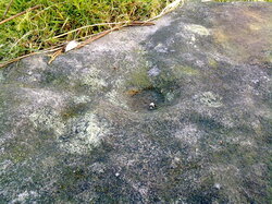
Cup mark on the cist cover in the centre of the circle.
