PECSAETAN
  • Home
  • News
  • Stone Circles
    • The Barbrook / Big moor Group >
      • Barbrook 1
      • Barbrook 2
      • Barbrook 3
    • The Eyam Moor Group >
      • Wet Withens
      • Eyam Moor 2
      • Eyam Moor 3
    • The Stanton Moor Group >
      • Doll Tor
      • Stanton Moor Central
      • Stanton Moor North
      • Ecclesall Woods 3
      • Stanton Moor South
      • The Nine Ladies
    • Ash Cabin Flat
    • Crook Hill
    • Bamford moor
    • Brown Edge
    • The Bullstones
    • Ewden Beck
    • Froggat edge / Stoke Flat
    • Gibbet Moor North
    • Hordron Edge
    • Lawrence field
    • Loxley Common (possible) stone circle.
    • Nine Stones Close
    • Parkgate Stone Circle
    • Smelting Hill
  • Henges
    • Arbor Low and Gib Hill
    • The Bull Ring
    • Twyford Henge and Round Hill
  • Standing Stones
    • Abney Moor
    • Bradbourne
    • Dol Tor standing stone
    • The Bradstone
    • Farley Moor
    • Gardoms Edge
    • The Murder Stone
    • New Hagg Standing Stone
    • Old womans stone
    • The Stoup
    • Whaley Bridge
    • Wirksworth Moor
  • Rock Art
    • Ashover
    • Ball Cross - Weston Park Museum
    • Barbrook 2 Chevron and Cup Marks
    • Big Moor Cup Stone
    • Bleakley Dyke - Weston Park Museum
    • Calton Pastures - Buxton Museum
    • Cup marked rock Stanage barrow
    • Dobb Edge
    • Ecclesall Woods >
      • Ecclesall Woods 1
      • Ecclesall Woods 2
      • Ecclesall Woods 3
    • Eyam moor group >
      • Eyam Moor / Stanage Barrow
      • Eyam Moor Barrow Cup Stone
      • Cup marked boulder
    • Great Hucklow
    • Gardoms Edge >
      • Gardoms Edge main panel
      • Gardom's Edge - Weston Park
      • Gardoms Edge Cup Stone
    • Harthill Moor >
      • Harthill moor cup Marked Rock
      • Harthill Moor Cup Marked Stone
    • Holymoorside cup Marked Boulder
    • Ladybower Tor
    • Redmires cup marked stone
    • Rowtor Rocks >
      • Rowtor Rocks Cup and Rings
      • Rowtor Rocks Flower Design
      • Rowtor Rocks Cup, Ring & Gutter
      • Rowtor rocks Serpent stone
      • Rowtor Rocks Serpent Stone 2
  • Rock shelters and Caves
    • Ash Cabin Rock Shelter / Cave
    • Ash Tree Cave
    • Bonsall Lane
    • Bunkers hill plantation
    • Calling Low Dale
    • Carsington Pasture Cave
    • Cheshire Wood Cave
    • Creswell Crags
    • Dowel Cave
    • Etches Cave
    • Fox Hole Cave
    • Frank 'Ith Rocks
    • Harboro' Rocks Cave
    • Langwith Basset Cave
    • Nan Tor
    • Rains Cave
    • Ravencliffe Cave
    • St Bertram's
    • Thirst House Cave
    • Thor's Cave >
      • Elderbush Cave
      • Seven Ways Cave
    • Sycamore Cave
  • Chambered tombs
    • Five Wells
    • Green Low Chambered Cairn
    • Harboro' Rocks
    • Minning Low
    • Stoney Low
    • Pea Low
    • Tides Low
  • Cairns Ringcairns and Barrows
    • Beeley South 1
    • Beeley Warren NW
    • Big Moor ( reconstructed) Cairn
    • Boars Low
    • Brushfield Hough
    • Ciceley Low
    • Eyam Moor Barrow
    • Gibbet Moor Cist
    • Gospel Hillocks Long Barrow
    • Graves Park Barrow
    • Green Low Ring Cairn
    • Harland Edge Round Cairn
    • Harrod Low Long Barrow
    • Hathersage Moor Barrow.
    • Hathersage moor Ring Cairn
    • Hob Hurst's House
    • Ladder Hill
    • Liffs Low
    • Lords Seat
    • Moscar Moor Kerb Cairn
    • Margery Hill Cairn
    • Perryfoot Long Barrow
    • Raventor Cairn & Cist
    • Raven Tor Triple Cairn
    • Reddicar Clough Long Cist
    • Rockhurst Long Barrow
    • Strawberry Lea
    • Swine Sty Cist
    • The Bridestones
    • The Tong Long Barrow
    • Three Men of Gardom's
    • Toads Mouth Cairn
    • Walders Low
    • White Rake Long Barrow
    • Wigber Low
  • Hill Forts Enclosures and Settlements
    • Ash Cabin Hill fort
    • Ball Cross
    • Castle Ring
    • Carl Wark
    • Castle Naze
    • Cowell Flats
    • Cranes Fort
    • Fin Cop
    • Gardoms Edge
    • Mam Tor Hill Fort
    • Markland Grips
    • Pin Dale Enclosure
    • Swine Sty
    • The Holmes Enclosure
    • Wincobank Hill Fort
  • Stones and Outcrops of Significance
    • Bradley Tor Rocking Stone
    • Cuckoo Stone
    • Durwood Tor
    • Eagle Stone
    • Rowtor Rocks Rocking stone
    • Robin Hood's Stride
    • Harboro' Rocks
    • The Alport Stone
    • The Headstone
    • Stanton moor >
      • The Andle Stone
      • The Gorse Stone
      • The Heart Stone
      • The Cat Stone
      • The Cork Stone
    • The Turning Stone & Robin Hood's Mark
  • Contact us
  • Links
    • The Peak District National Park Authority
    • The National Trust Derbyshire
    • The National Trust Yorkshire
    • Staffordshire archaelogical service
  • Pecsaetan slideshow.
  • Guest book

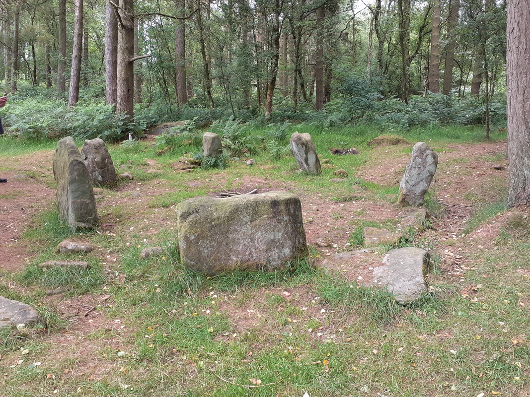
Doll Tor Stone Circle

Stanton Moor
Derbyshire
OS Grid Reference - SK 2384 6288
From Bakewell take the A6 Matlock road, follow this till just past the signs for Haddon Hall where you take a right, the first major junction for Youlgreave, the B5056, then after about 1km take the first left over the bridge. You then need the first left you come to signposted Stanton-in-the-Peak.
Your now on Birchover road, just follow the road for around 2km where once up through the village you'll find yourself in open countryside, after a long straight stretch of road you'll rise up to the high point of the moor, there just over the wall in a field to your right by a small parking spot lays the Andle stone, there's alternative parking around 150 metres further along the road.
Make your way over to the Andle stone then head down hill to it's left, go through the gate then head for the bottom left corner of this field where you'll find a gateway with a metal gate the other side, through the gate and around 50 metres downhill lays Doll Tor circle just in the woodland to your left.
Please note: Located within 20 metres of the circle is a disused quarry, children should not be allowed to wander alone.
Picture
Powered by Create your own unique website with customizable templates.