PECSAETAN
  • Home
  • News
  • Stone Circles
    • The Barbrook / Big moor Group >
      • Barbrook 1
      • Barbrook 2
      • Barbrook 3
    • The Eyam Moor Group >
      • Wet Withens
      • Eyam Moor 2
      • Eyam Moor 3
    • The Stanton Moor Group >
      • Doll Tor
      • Stanton Moor Central
      • Stanton Moor North
      • Ecclesall Woods 3
      • Stanton Moor South
      • The Nine Ladies
    • Ash Cabin Flat
    • Crook Hill
    • Bamford moor
    • Brown Edge
    • The Bullstones
    • Ewden Beck
    • Froggat edge / Stoke Flat
    • Gibbet Moor North
    • Hordron Edge
    • Lawrence field
    • Loxley Common (possible) stone circle.
    • Nine Stones Close
    • Parkgate Stone Circle
    • Smelting Hill
  • Henges
    • Arbor Low and Gib Hill
    • The Bull Ring
    • Twyford Henge and Round Hill
  • Standing Stones
    • Abney Moor
    • Bradbourne
    • Dol Tor standing stone
    • The Bradstone
    • Farley Moor
    • Gardoms Edge
    • The Murder Stone
    • New Hagg Standing Stone
    • Old womans stone
    • The Stoup
    • Whaley Bridge
    • Wirksworth Moor
  • Rock Art
    • Ashover
    • Ball Cross - Weston Park Museum
    • Barbrook 2 Chevron and Cup Marks
    • Big Moor Cup Stone
    • Bleakley Dyke - Weston Park Museum
    • Calton Pastures - Buxton Museum
    • Cup marked rock Stanage barrow
    • Dobb Edge
    • Ecclesall Woods >
      • Ecclesall Woods 1
      • Ecclesall Woods 2
      • Ecclesall Woods 3
    • Eyam moor group >
      • Eyam Moor / Stanage Barrow
      • Eyam Moor Barrow Cup Stone
      • Cup marked boulder
    • Great Hucklow
    • Gardoms Edge >
      • Gardoms Edge main panel
      • Gardom's Edge - Weston Park
      • Gardoms Edge Cup Stone
    • Harthill Moor >
      • Harthill moor cup Marked Rock
      • Harthill Moor Cup Marked Stone
    • Holymoorside cup Marked Boulder
    • Ladybower Tor
    • Redmires cup marked stone
    • Rowtor Rocks >
      • Rowtor Rocks Cup and Rings
      • Rowtor Rocks Flower Design
      • Rowtor Rocks Cup, Ring & Gutter
      • Rowtor rocks Serpent stone
      • Rowtor Rocks Serpent Stone 2
  • Rock shelters and Caves
    • Ash Cabin Rock Shelter / Cave
    • Ash Tree Cave
    • Bonsall Lane
    • Bunkers hill plantation
    • Calling Low Dale
    • Carsington Pasture Cave
    • Cheshire Wood Cave
    • Creswell Crags
    • Dowel Cave
    • Etches Cave
    • Fox Hole Cave
    • Frank 'Ith Rocks
    • Harboro' Rocks Cave
    • Langwith Basset Cave
    • Nan Tor
    • Rains Cave
    • Ravencliffe Cave
    • St Bertram's
    • Thirst House Cave
    • Thor's Cave >
      • Elderbush Cave
      • Seven Ways Cave
    • Sycamore Cave
  • Chambered tombs
    • Five Wells
    • Green Low Chambered Cairn
    • Harboro' Rocks
    • Minning Low
    • Stoney Low
    • Pea Low
    • Tides Low
  • Cairns Ringcairns and Barrows
    • Beeley South 1
    • Beeley Warren NW
    • Big Moor ( reconstructed) Cairn
    • Boars Low
    • Brushfield Hough
    • Ciceley Low
    • Eyam Moor Barrow
    • Gibbet Moor Cist
    • Gospel Hillocks Long Barrow
    • Graves Park Barrow
    • Green Low Ring Cairn
    • Harland Edge Round Cairn
    • Harrod Low Long Barrow
    • Hathersage Moor Barrow.
    • Hathersage moor Ring Cairn
    • Hob Hurst's House
    • Ladder Hill
    • Liffs Low
    • Lords Seat
    • Moscar Moor Kerb Cairn
    • Margery Hill Cairn
    • Perryfoot Long Barrow
    • Raventor Cairn & Cist
    • Raven Tor Triple Cairn
    • Reddicar Clough Long Cist
    • Rockhurst Long Barrow
    • Strawberry Lea
    • Swine Sty Cist
    • The Bridestones
    • The Tong Long Barrow
    • Three Men of Gardom's
    • Toads Mouth Cairn
    • Walders Low
    • White Rake Long Barrow
    • Wigber Low
  • Hill Forts Enclosures and Settlements
    • Ash Cabin Hill fort
    • Ball Cross
    • Castle Ring
    • Carl Wark
    • Castle Naze
    • Cowell Flats
    • Cranes Fort
    • Fin Cop
    • Gardoms Edge
    • Mam Tor Hill Fort
    • Markland Grips
    • Pin Dale Enclosure
    • Swine Sty
    • The Holmes Enclosure
    • Wincobank Hill Fort
  • Stones and Outcrops of Significance
    • Bradley Tor Rocking Stone
    • Cuckoo Stone
    • Durwood Tor
    • Eagle Stone
    • Rowtor Rocks Rocking stone
    • Robin Hood's Stride
    • Harboro' Rocks
    • The Alport Stone
    • The Headstone
    • Stanton moor >
      • The Andle Stone
      • The Gorse Stone
      • The Heart Stone
      • The Cat Stone
      • The Cork Stone
    • The Turning Stone & Robin Hood's Mark
  • Contact us
  • Links
    • The Peak District National Park Authority
    • The National Trust Derbyshire
    • The National Trust Yorkshire
    • Staffordshire archaelogical service
  • Pecsaetan slideshow.
  • Guest book

Parkgate stone circle, Beeley moor

Location -
Beeley moor
Derbyshire
OS Grid reference - SK 28043 68504

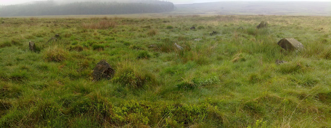
Located on Beeley moor high above the village of Beeley this embanked circle is rather well preserved though the larger stones are now leaning and some of the smaller stones are obscured by the tall grass.
On site defining the circle is easy once you managed to find it. !

From the access point (detailed below) follow the main track till the first gentle turn to the right, head off to your right N/NNE - ish towards the corner / end of the Bunkers hill plantation where you should be able to spot the larger stones, there is a rough path leading by the circle which should help you locate it.

To find the site you need to travel up through Beeley village and follow the road for around 2km, parking is by the
roadside at Hell Bank plantation, as you leave the narrow twisty part of the lane and emerge back out the other side of the trees you'll notice a sharp right hand bend in the road and a track off to the left, walk along the track, which can be very muddy, for around 700 metres till you see the entrance for Beeley moor, there's a large wooden gate and a stone stile / steps.


Picture
Powered by Create your own unique website with customizable templates.