PECSAETAN
  • Home
  • News
  • Stone Circles
    • The Barbrook / Big moor Group >
      • Barbrook 1
      • Barbrook 2
      • Barbrook 3
    • The Eyam Moor Group >
      • Wet Withens
      • Eyam Moor 2
      • Eyam Moor 3
    • The Stanton Moor Group >
      • Doll Tor
      • Stanton Moor Central
      • Stanton Moor North
      • Ecclesall Woods 3
      • Stanton Moor South
      • The Nine Ladies
    • Ash Cabin Flat
    • Crook Hill
    • Bamford moor
    • Brown Edge
    • The Bullstones
    • Ewden Beck
    • Froggat edge / Stoke Flat
    • Gibbet Moor North
    • Hordron Edge
    • Lawrence field
    • Loxley Common (possible) stone circle.
    • Nine Stones Close
    • Parkgate Stone Circle
    • Smelting Hill
  • Henges
    • Arbor Low and Gib Hill
    • The Bull Ring
    • Twyford Henge and Round Hill
  • Standing Stones
    • Abney Moor
    • Bradbourne
    • Dol Tor standing stone
    • The Bradstone
    • Farley Moor
    • Gardoms Edge
    • The Murder Stone
    • New Hagg Standing Stone
    • Old womans stone
    • The Stoup
    • Whaley Bridge
    • Wirksworth Moor
  • Rock Art
    • Ashover
    • Ball Cross - Weston Park Museum
    • Barbrook 2 Chevron and Cup Marks
    • Big Moor Cup Stone
    • Bleakley Dyke - Weston Park Museum
    • Calton Pastures - Buxton Museum
    • Cup marked rock Stanage barrow
    • Dobb Edge
    • Ecclesall Woods >
      • Ecclesall Woods 1
      • Ecclesall Woods 2
      • Ecclesall Woods 3
    • Eyam moor group >
      • Eyam Moor / Stanage Barrow
      • Eyam Moor Barrow Cup Stone
      • Cup marked boulder
    • Great Hucklow
    • Gardoms Edge >
      • Gardoms Edge main panel
      • Gardom's Edge - Weston Park
      • Gardoms Edge Cup Stone
    • Harthill Moor >
      • Harthill moor cup Marked Rock
      • Harthill Moor Cup Marked Stone
    • Holymoorside cup Marked Boulder
    • Ladybower Tor
    • Redmires cup marked stone
    • Rowtor Rocks >
      • Rowtor Rocks Cup and Rings
      • Rowtor Rocks Flower Design
      • Rowtor Rocks Cup, Ring & Gutter
      • Rowtor rocks Serpent stone
      • Rowtor Rocks Serpent Stone 2
  • Rock shelters and Caves
    • Ash Cabin Rock Shelter / Cave
    • Ash Tree Cave
    • Bonsall Lane
    • Bunkers hill plantation
    • Calling Low Dale
    • Carsington Pasture Cave
    • Cheshire Wood Cave
    • Creswell Crags
    • Dowel Cave
    • Etches Cave
    • Fox Hole Cave
    • Frank 'Ith Rocks
    • Harboro' Rocks Cave
    • Langwith Basset Cave
    • Nan Tor
    • Rains Cave
    • Ravencliffe Cave
    • St Bertram's
    • Thirst House Cave
    • Thor's Cave >
      • Elderbush Cave
      • Seven Ways Cave
    • Sycamore Cave
  • Chambered tombs
    • Five Wells
    • Green Low Chambered Cairn
    • Harboro' Rocks
    • Minning Low
    • Stoney Low
    • Pea Low
    • Tides Low
  • Cairns Ringcairns and Barrows
    • Beeley South 1
    • Beeley Warren NW
    • Big Moor ( reconstructed) Cairn
    • Boars Low
    • Brushfield Hough
    • Ciceley Low
    • Eyam Moor Barrow
    • Gibbet Moor Cist
    • Gospel Hillocks Long Barrow
    • Graves Park Barrow
    • Green Low Ring Cairn
    • Harland Edge Round Cairn
    • Harrod Low Long Barrow
    • Hathersage Moor Barrow.
    • Hathersage moor Ring Cairn
    • Hob Hurst's House
    • Ladder Hill
    • Liffs Low
    • Lords Seat
    • Moscar Moor Kerb Cairn
    • Margery Hill Cairn
    • Perryfoot Long Barrow
    • Raventor Cairn & Cist
    • Raven Tor Triple Cairn
    • Reddicar Clough Long Cist
    • Rockhurst Long Barrow
    • Strawberry Lea
    • Swine Sty Cist
    • The Bridestones
    • The Tong Long Barrow
    • Three Men of Gardom's
    • Toads Mouth Cairn
    • Walders Low
    • White Rake Long Barrow
    • Wigber Low
  • Hill Forts Enclosures and Settlements
    • Ash Cabin Hill fort
    • Ball Cross
    • Castle Ring
    • Carl Wark
    • Castle Naze
    • Cowell Flats
    • Cranes Fort
    • Fin Cop
    • Gardoms Edge
    • Mam Tor Hill Fort
    • Markland Grips
    • Pin Dale Enclosure
    • Swine Sty
    • The Holmes Enclosure
    • Wincobank Hill Fort
  • Stones and Outcrops of Significance
    • Bradley Tor Rocking Stone
    • Cuckoo Stone
    • Durwood Tor
    • Eagle Stone
    • Rowtor Rocks Rocking stone
    • Robin Hood's Stride
    • Harboro' Rocks
    • The Alport Stone
    • The Headstone
    • Stanton moor >
      • The Andle Stone
      • The Gorse Stone
      • The Heart Stone
      • The Cat Stone
      • The Cork Stone
    • The Turning Stone & Robin Hood's Mark
  • Contact us
  • Links
    • The Peak District National Park Authority
    • The National Trust Derbyshire
    • The National Trust Yorkshire
    • Staffordshire archaelogical service
  • Pecsaetan slideshow.
  • Guest book

Gardoms Edge Standing Stone

Location - Gardoms Edge
Derbyshire
OS Grid Reference SK272 732

From Owler Bar take the A621 Sheffield road till it's end, you then need the A619.
After around 2 miles take the B6050 for around 100 metres and park by The Robin Hood public house, there's a free car park for around a dozen cars.
From here head back down the B6050 and turn right onto the A619, the foorpath you'll need is around 200 metres on your right and is signposted.

Follow the path uphill to the first set of stone gate posts, here you turn right and once again head uphill.
a little further on you'll pass through a second set of stone gate posts where you'll then need to follow the edge, if you're on the right track you'll pass the 3 Men of Gardoms, 3 small cairns in a line.
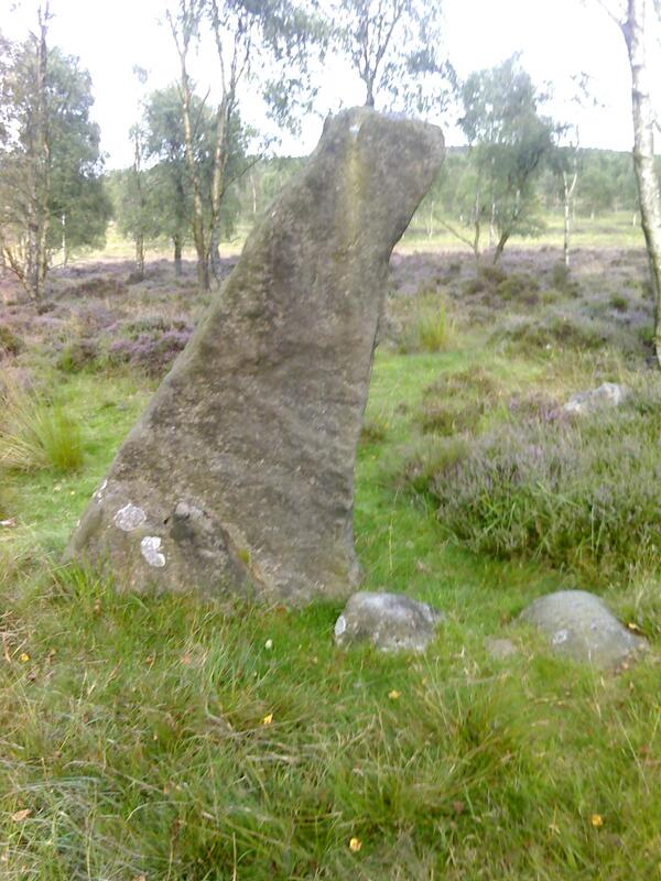
Just follow the edge for several hundred metres till the wall to your right is replaced with a wire fence, here you'll find a gate that's set back in a corner, head through this and follow the path, the standing stone is located about 150 metres along the path and is difficult to miss, standing around two metres tall.

Picture
Powered by Create your own unique website with customizable templates.